Plunging Houses and Powering Homes
August of 1916 was a fateful month for Claiborne County, north-east of what is now Norris, Tennessee. On the third of the month, around 8pm, the burgeoning waters of Big Barren Creek thundered forth and annihilated the small dam which had once stood upriver of several small east Tennessee communities. Four local mills, five homes, and three barns were destroyed immediately. Trains leaving Knoxville became trapped at Oakman, where conductors witnessed ten miles of flooded tracks. "Whole families are taken," the Knoxville News Sentinel reported, "and livestock are destroyed." Crockett Edmondson, a local resident, was awakened by his wife's screams as flood waters burst into their new two-story home and filled the house with water up to Crockett's knees. Struck by his collapsing ceiling before he could get to the couple's baby, Crockett was washed over a mile downstream, lapsing in and out of consciousness and sustaining severe injuries. Finally, he ended up in the safety of a neighbor's hilltop home. He was too injured and bone-weary to recognize it. The disaster claimed the life of Crockett's wife and three of his children. And the Edmondson family was far from the only one to be torn apart that day. After the flood waters had settled, the final death toll was twenty four souls. The communities on Barren Creek itself became "isolated and almost inaccessible to the outside world." This devastating event would later be known as the Barren Creek Flood.
Twenty years later, Barren Creek, along with many other small communities in the Norris area, would be buried underwater again. Only this time, the burial would be permanent and the floods would be man-made. Norris Dam, completed in 1936, necessitated the relocation of over a thousand families away from soon-to-be lakes and rivers that would be flooded once the dam was completed. The small town of Loyston was over a hundred years old when the TVA came in 1933. With "a mill, two stores, two churches, a post office, a grammar school and a high school" and about 70 residents, Loyston was typical of the small, largely unelectrified villages that dotted the Tennessee Valley. Alas, it lay in the floodpath. The village was "so located that protection against floodwaters was beyond the remotest possibility." Small as it was, the TVA sent men to photograph the location, interview the inhabitants, help resettle them, and then "bought [Loyston] outright." Interestingly, the townspeople did not go far after resettlement. Most Loystonites moved just four miles south and founded New Loyston. Once Norris Dam was completed, the old village, buildings and all, was submerged under what is now called the "Loyston Sea." Although it left many old communities underwater, one of the TVA's central missions was to provide flood control for the region and prevent future disasters like the Barren Creek Flood. A huge, 265-foot tall federally funded dam like Norris dam could withstand storms and floods that local constructions simply could not. Since the 1930's, Norris Dam has largely abated the worst floods in East Tennessee. In February of 2025 alone, the dam held back 20 feet of water and prevented $89 million in potential damages to the region.
But the new dam was about more than just flood control. When the TVA began laying the groundwork for the Norris Dam in 1933, only 3 percent of farms in the Tennessee Valley had electricity. Many farmers and villagers were living in extremely impoverished conditions, and East Tennessee was often considered to be one of the poorest and most destitute places in the country. Annual per-capita income was just $168 a year (about $4,500 today). Worse yet, the aforementioned regular flooding brought sickness and disease into the region's crops, resulting in malaria rates as high as 30% in some locations. The Great Depression only made things worse for the already poverty-stricken region. The Tennessee Valley Authority saw the hydroelectric dam as an all-encompasing solution to the malaise that hung over East Tennessee. In 1934, the TVA had just over six and a half thousand customers. Six years after the completion of the Norris Dam in 1942, that number ballooned to nearly five hundred thousand.
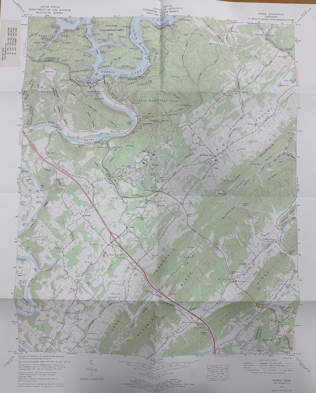
The image above is a map of the Norris Quadrangle, created in 1929 and updated in 1973 by the TVA in service of the upcoming Norris Dam construction effort. Roads, cemeteries, the planned dam location, and more are included on the map. In order to undertake this massive construction and evacuation effort, the agency needed good topographical data. Remnants of the pre-TVA Norris area still remain: note "Loyston Dike" near the upper right hand corner of the map
Links to sources used (in order of appearance):
Various Knoxville News Sentinel articles, accesable via Joe Payne geneology: https://joepayne.org/flood.htm
TVA: https://www.tva.com/energy/our-power-system/hydroelectric/norris
The Tennessee Magazine: https://www.tnmagazine.org/tennessees-underwater-ghost-towns/
TVA's "The Norris Project: a comprehensive report on the planning, design, construction, and initial operations of the Tennessee Valley Authority's first water control project, accessible via Hathi Trust: https://babel.hathitrust.org/cgi/pt?id=rul.39030014724134&seq=552
6 News: https://www.wate.com/news/anderson-county-news/tva-says-norris-dam-prevented-89-million-in-flood-damage/
Freeman, "Roosevelt’s TVA: The Development Program that Transformed a Region and Inspired the World": https://americansystemnow.com/how-the-tva-transformed-the-tennessee-valley/?print=print
Knoxville News Sentinel: https://archive.knoxnews.com/news/local/tvas-legacy-region-rose-from-poverty-to-prosperity-ep-411654291-359898501.html/